Availability and variability of groundwater resources in arid and semiarid environments
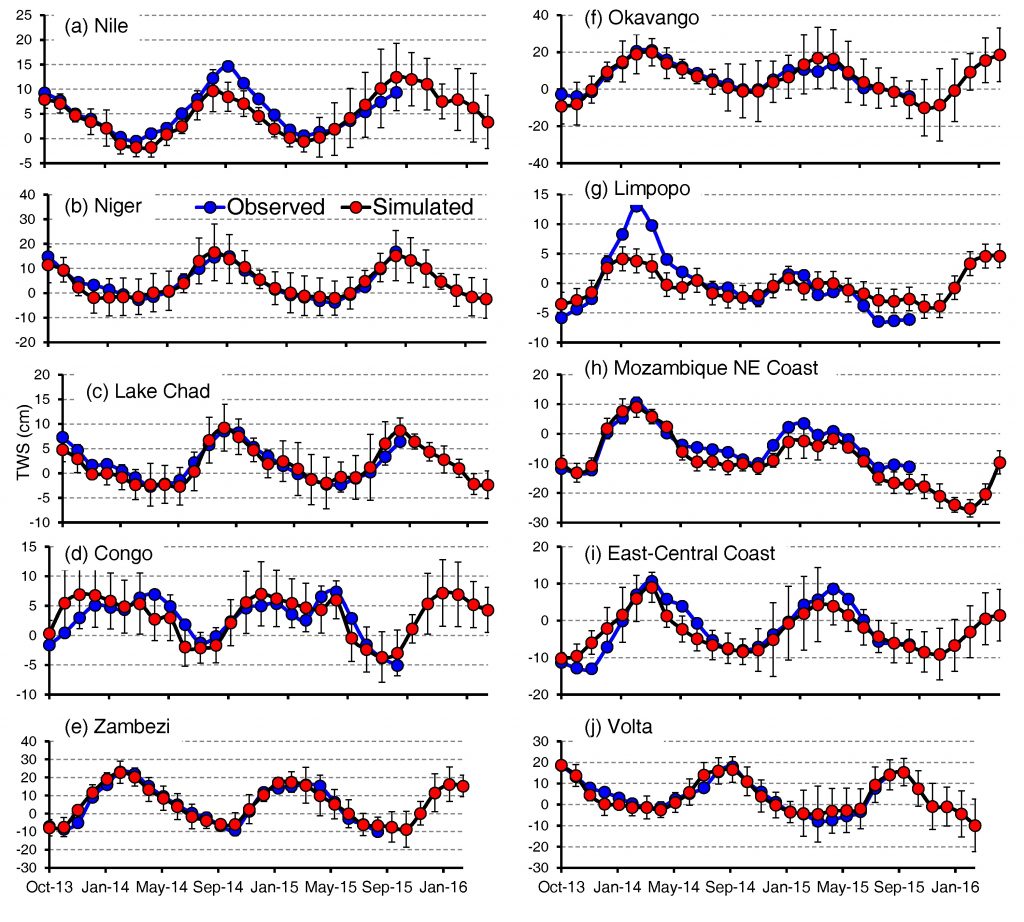
We use the gravity recovery and climatic experiment (GRACE), land surface models (e.g., GLDAS, CLM), soil moisture (e.g., SMAP), and rainfall (e.g., GPM, TRMM) datasets along with GIS technologies to examine spatiotemporal variability in groundwater resources in arid, semi-arid, and coastal environments; explore the nature of factors (e.g., climatic and/or human pressure-related) controlling this variability; and provide sustainable management scenarios for these resources. These exercises have been conducted on regional (Africa), national (e.g., Egypt, Saudi Arabia, Morocco, China), and local (e.g., Texas, Areal Sea) scales.
Publications:
- Ahmed, M., Wiese, D., 2019, Short-term trends in Africa’s freshwater resources: Magnitudes and drivers, Science of the Total Environment, v. 695, p. 133843,doi: https://doi.org/10.1016/j.scitotenv.2019.133843
- Niyazi, B., Ahmed, M., Masoud, M., Rashed, M., Basahi, J., 2019, Sustainable and resilient management scenarios for groundwater resources of the Red Sea coastal aquifers, Science of the Total Environment, v. 690, p. 1310–1320, doi: https://doi.org/10.1016/j.scitotenv.2019.07.081
- Sultan, M., Sturchio, N., Alsefry, S., Emil, M., Ahmed, M., Fathy, K., AbuAbdullah, M., Bettadpur, S., Save, H., Othman, A., Chouinard, K., 2019, Assessment of age, origin, and sustainability of fossil aquifers: A geochemical and remote sensing–based approach, Journal of Hydrology, v. 576, p. 325-341,doi: 10.1016/j.jhydrol.2019.06.017.
- Abdelmohsen, K., Sultan, M., Ahmed, M., Save, H., Elkaliouby, B., Emil, M., Yan, E., Abotalib, A., Krishnamurthy, R., Abdelmalik, K., 2019, Response of deep aquifers to climate variability, Science of the Total Environment, v. 677, p. 530-544, doi: 10.1016/j.scitotenv.2019.04.316.
- Niyazi, B., Ahmed, M., Basahi, J., Masoud, M., Rashed, M., 2018, Spatiotemporal trends in freshwater availability in the Red Sea Hills, Saudi Arabia, Arabian Journal of Geosciences, v. 702, p. 1-13, doi: 10.1007/s12517-018-4052-y.
- Fallatah, O., Ahmed M., Cardace, D., Boving, T., Akanda, A., 2018, Assessment of Modern Recharge to Arid Region Aquifers Using Integrated Geophysical, Geochemical, and Remote Sensing Approaches, Journal of Hydrology, v. 569, p. 600 – 611, doi: 10.1016/j.jhydrol.2018.09.061.
- Ahmed, M., Abdelmohsen, K., 2018, Quantifying Modern Recharge and Depletion Rates of the Nubian Aquifer in Egypt, Surveys in Geophysics, v. 39, p. 729-751, doi: 10.1007/s10712-018-9465-3
- Fallatah, O., Ahmed M., Save, H., Akanda, A., 2017, Quantifying Temporal Variations in Water Resources of a Vulnerable Middle Eastern Transboundary Aquifer System. Hydrological Processes, v. 31, p. 4081-4091, doi: 10.1002/hyp.11285.
- Ebead, B., Ahmed, M., Niu, Z., Huang, N., 2017, Quantifying the anthropogenic impact on groundwater resources of North China using GRACE and land surface models: Journal of Applied Remote Sensing,doi:10.1117/1.JRS.11.026029.
- Mohamed, A., Sultan, M., Ahmed M., Yan, E., Ahmed, E., 2016, Aquifer recharge, depletion, and connectivity: inferences from GRACE, land surface models, geochemical, and geophysical data. Geological Society of America Bulletin, v. 129, p. 534-546, doi: 10.1130/B31460.1.
- Ahmed, M., Sultan, M., Wahr, J., Yan, E., 2014, The use of GRACE data to monitor natural and anthropogenic induced variations in water availability across Africa: Earth Science Reviews, v. 136, p. 289–300, https://doi.org/10.1016/j.earscirev.2014.05.009
- Sultan, M., Ahmed, M., Wahr, J., Yan, E., Emil, M., 2015, Monitoring Aquifer Depletion from Space: Case Studies from the Saharan and Arabian Aquifers, in Lakshmi, V., (Ed.), Remote Sensing of the Terrestrial Water Cycle, AGU Geophysical Monograph # 206, p. 347-366, doi: 10.1002/9781118872086.
- Sultan, M., Ahmed, M., Sturchio, N., Yan, Y., Milewski, A., Becker, R., Wahr, J., Becker, D., Chouinard, K., 2013, Assessment of the Vulnerabilities of the Nubian Sandstone Fossil Aquifer, North Africa, in Roger A. Pielke (Ed.), Climate Vulnerability: Understanding and Addressing Threats to Essential Resources. Elsevier Inc., Academic Press, p. 311–333, ISBN: 978-0-12-384704-1
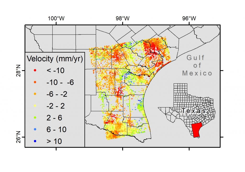
Map land subsidence rates and locations
We use Synthetic Aperture Radar (SAR) datasets (e.g., Envisat-ASAR, Sentinel-1, and ALOS-1 PALSAR) along with Interferometric Synthetic Aperture Radar (InSAR) techniques (e.g., small baseline subset, persistent scatterer interferometry) to map the spatiotemporal variability in land subsidence rates and investigate factors controlling these variabilities (e.g., sediment compaction, faulting, salt tectonics, and fluid withdrawal) in coastal Texas. Temporal gravity and GPS data are also used to validate/calibrate InSAR-derived subsidence rates.
- Haley, M., Ahmed, M., Gebermichael, E, Murgulet, D., Starek, M., 2022, Land Subsidence in the Texas Coastal Bend: Locations, Rates, Triggers, and Consequences: Remote Sensing, v. 14, p. 192. https://doi.org/10.3390/rs14010192.
- Qiao*, X., Chu, T., Tissot, P., Ali, I., Ahmed, M., 2023, Vertical land motion monitored with satellite radar altimetry and tide gauge along the Texas coastline, USA, between 1993 and 2020, International Journal of Applied Earth Observation and Geoinformation, v. 117, p. 103222, doi: https://doi.org/10.1016/j.jag.2023.103222.
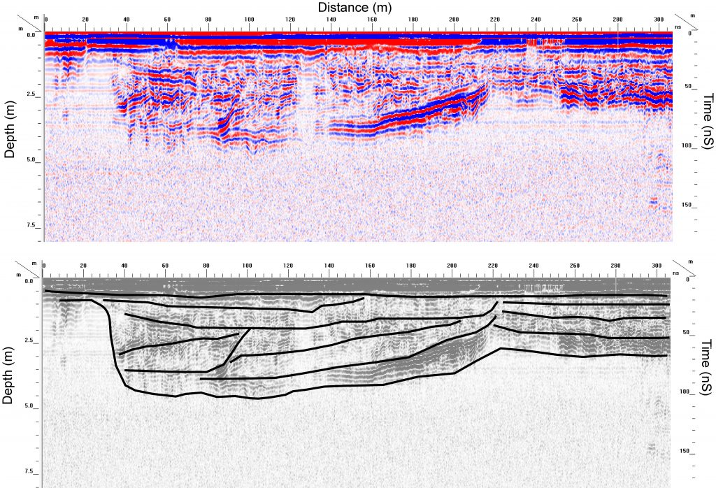
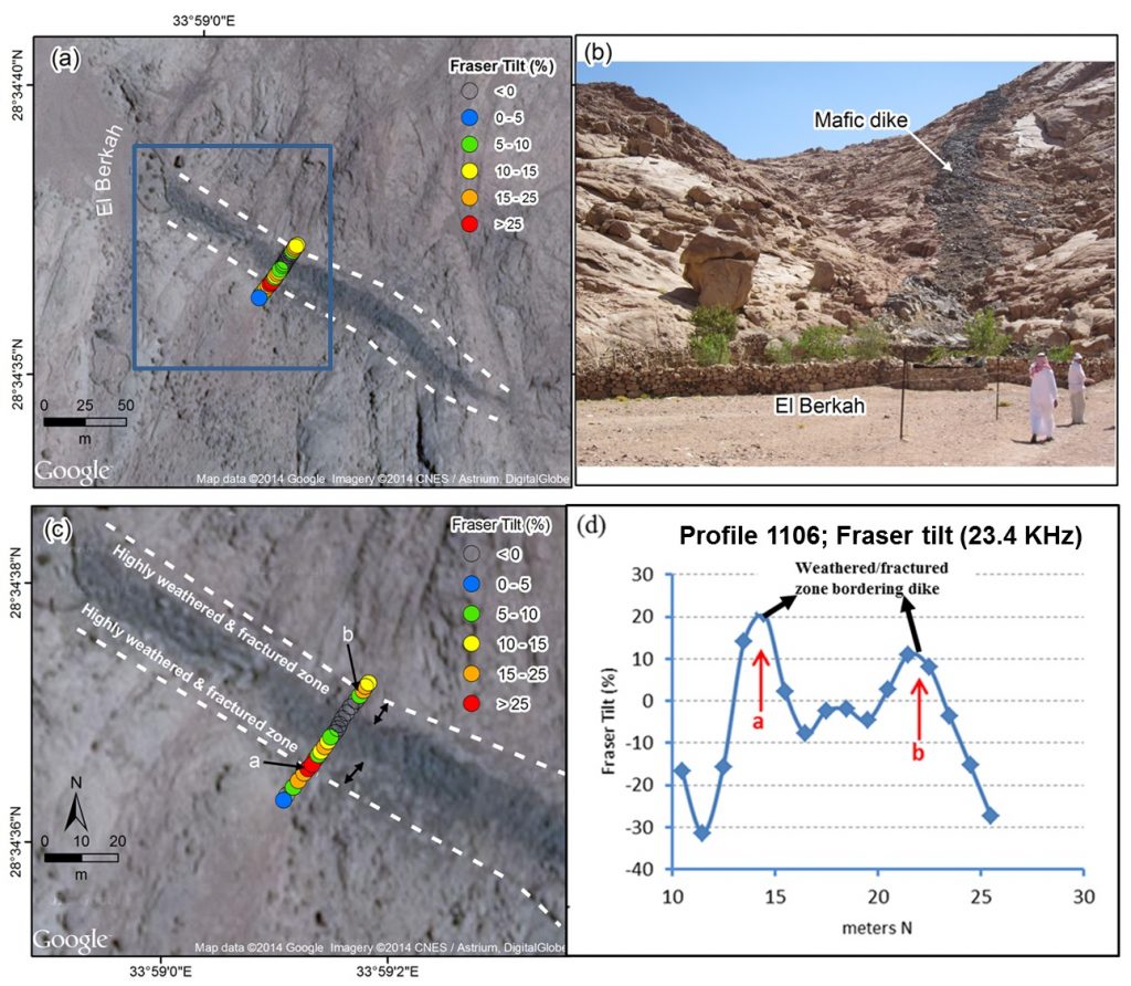
Investigate the subsurface controls on coastal morphology
We use geophysical (GPR, time- and frequency-domain electromagnetic, electric) and radar remote sensing datasets to investigate how the antecedent geological (e.g., sediment types and structures) and stratigraphic (e.g., paleochannels) features vary spatially (along-shore, cross-shore, and with depth) within coastal systems and explore the control of this variability on the dune morphology and barrier island breaching in coastal Texas.
- Abdelrehim*, R., Ahmed©, M., Everett, M., 203, Hydrogeological Controls on Barrier Island Geomorphology: Insights from Electromagnetic Surveys, The Leading Edge
- Essam*, D., Ahmed©, M., Abouelmagd A., Soliman, F., 2020, Monitoring temporal variations in groundwater levels in urban areas using Ground Penetrating Radar, Science of the Total Environment, v. 703, p. 134986, doi: https://doi.org/10.1016/j.scitotenv.2019.134986
- Turner, R., Ahmed, M., 2019, Structural and stratigraphic controls on reservoir quality and distribution of the Oligocene Vicksburg formation, Brooks county, Texas: AGU, San Francisco, CA, Dec. 2019.
- Colmenero, D., Ahmed, M., Zavala, L., 2019, Subsurface characterization of Padre Island using Ground Penetrating Radar (GPR) and Electrical Resistivity Imaging (ERI): Society of Exploration Geophysicists (SEG), San Antonito, TX, Sep. 2019.
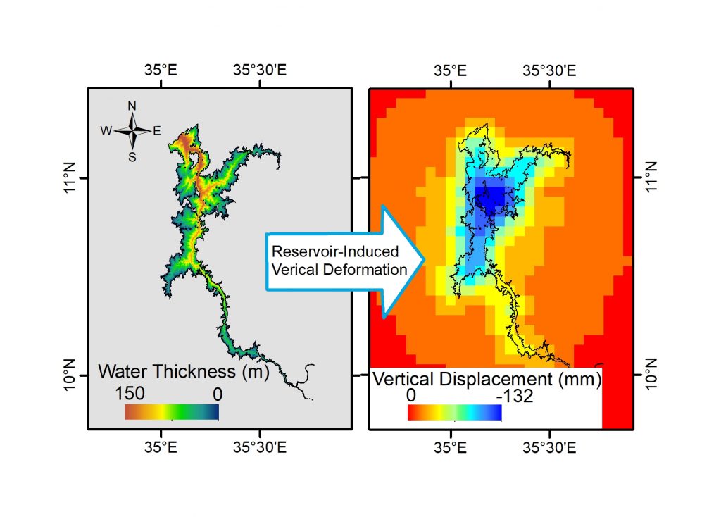
Characterize reservoir-induced environmental and economic impacts
We use remote sensing data and statistical models to characterize the environmental and economic impacts of the Grand Ethiopian Renaissance Dam (GERD) in Africa. We predicted large-scale land deformation induced by the construction of the GERD reservoir in Ethiopia. We also projected losses in Egypt’s annual water allocation, agricultural lands, and macroeconomic variables due to the recent construction of the GERD in the Nile River basin.
- Kamara, A., Ahmed©, M., Benevides*, A., 2022, Environmental and Economic Impact of the Grand Ethiopian Renaissance Dam in Africa: Water, v. 14, p. 312, doi: https://doi.org/10.3390/w14030312. (IF 2020: 3.103)
- Chen**, Y., Ahmed©, M., Tangdamrongsub, N., Murgulet, D., 2021, Reservoir-Induced Land Deformation: Case Study from the Grand Ethiopian Renaissance Dam, Remote Sensing, v. 13, p. 874, doi: https://doi.org/10.3390/rs13050874
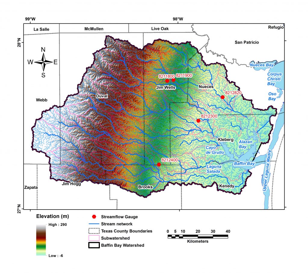
Characterize water quality in coastal estuaries
We use remote sensing datasets (e.g., Landsat and ECOSTRESS) to extract water quality indicators (e.g., salinity, turbidity, temperature, and chlorophyll-a) and use these indicators to generate high-resolution mariculture suitability indices for Texas estuaries. We also use continuous rainfall-runoff models (e.g., SWAT) to model the spatial and temporal variability of nutrients, sediments, and water loadings into Texas estuaries and quantify their projected changes in response to climate changes and anthropogenic activities.
- Abdelrehim*, R., Ahmed©, M., Everett, M., 203, Quantification of Surface Runoff, Nutrients, and Sediments Yield from a Semiarid Coastal Watershed Using the SWAT Model, Journal of Hydrology – Regional Studies, in review.
Construct a geophysical test site (GTS) for research and education purposes
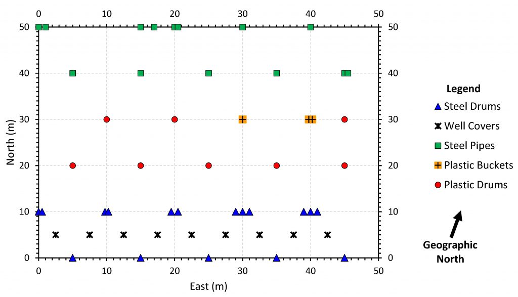
We constructed a GTS that contains subsurface targets of known materials (e.g., steel drums, plastic drums, plastic buckets, steel pipes, and well covers), orientations, and depths to create unique opportunities for geophysical research, training, and educational activities. These sites provide platforms to investigate the penetration and resolution of different geophysical techniques for characterizing the shallow subsurface. GTS-based field exercises represent an interesting, motivating, rewarding, and enjoyable experience for students and instructors.
- Ahmed, M., Turner, R., Haley, M., Shyrigh, S., Colmenero, D., Penchala, T., 2020, Constructing a Geophysical Test Site for Coastal Community’s Research and Education Activities, The Leading Edge, v. 40, p. 2.8-2.13, doi: https://doi.org/10.1190/tle40030208.1
Investigate groundwater recharge conditions and rates
We use geophysical (magnetic, electromagnetic, electric, gravity), remote sensing (visible, radar, thermal), and geochemical (stable and radiogenic isotopes) datasets along with continuous rainfall-runoff models (e.g., SWAT) and GIS technologies to delineate the spatial distribution of recharge areas; model the partitioning of precipitation into runoff, evaporation, and recharge; quantify spatiotemporal variability in recharge rates; investigate favorable recharge conditions; quantify recharge response to projected climate changes and man-made forces; and explore the role of geologic structures (i.e., shear zones, faults) in controlling groundwater accumulation and flow in clastic, carbonate, and basement aquifer systems in the Middle East and North Africa (MENA) and Mojave Desert regions.
Publications:
- Niyazi, B., Ahmed, M., Masoud, M., Rashed, M., Basahi, J., 2019, Sustainable and resilient management scenarios for groundwater resources of the Red Sea coastal aquifers, Science of the Total Environment, v. 690, p. 1310–1320, doi: https://doi.org/10.1016/j.scitotenv.2019.07.081
- Sultan, M., Sturchio, N., Alsefry, S., Emil, M., Ahmed, M., Fathy, K., AbuAbdullah, M., Bettadpur, S., Save, H., Othman, A., Chouinard, K., 2019, Assessment of age, origin, and sustainability of fossil aquifers: A geochemical and remote sensing–based approach, Journal of Hydrology, v. 576, p. 325-341,doi: 10.1016/j.jhydrol.2019.06.017.
- Abdelmohsen, K., Sultan, M., Ahmed, M., Save, H., Elkaliouby, B., Emil, M., Yan, E., Abotalib, A., Krishnamurthy, R., Abdelmalik, K., 2019, Response of deep aquifers to climate variability, Science of the Total Environment, v. 677, p. 530-544, doi: 10.1016/j.scitotenv.2019.04.316.
- Fallatah, O., Ahmed M., Cardace, D., Boving, T., Akanda, A., 2018, Assessment of Modern Recharge to Arid Region Aquifers Using Integrated Geophysical, Geochemical, and Remote Sensing Approaches, Journal of Hydrology, v. 569, p. 600 – 611, doi: 10.1016/j.jhydrol.2018.09.061.
- Ahmed, M., Abdelmohsen, K., 2018, Quantifying Modern Recharge and Depletion Rates of the Nubian Aquifer in Egypt, Surveys in Geophysics, v. 39, p. 729-751, doi: 10.1007/s10712-018-9465-3
- Mohamed, A., Sultan, M., Ahmed M., Yan, E., Ahmed, E., 2016, Aquifer recharge, depletion, and connectivity: inferences from GRACE, land surface models, geochemical, and geophysical data. Geological Society of America Bulletin, v. 129, p. 534-546, doi: 10.1130/B31460.1.
- Mohamed, L., Sultan, M., Ahmed, M., Zaki, A., Sauck, W., Soliman, F., Yan, E., Elkadiri, R., Aboelmagd, A., 2015, Structural controls on groundwater flow in basement terrains: Geophysical, remote sensing, and field investigations in Sinai: Surveys in Geophysics, v. 36, p. 717–742, doi: 10.1007/s10712-015-9331-5.
- Dailey, D., Sauck, W., Sultan, M., Milewski, A., Ahmed, M., Laton, R., Foster, J., Elkederi, R., Schmidt, C., Alharbi, T., 2015, Geophysical, remote sensing, GIS, and geochemical applications for a better understanding of the structural controls on groundwater flow in the Mojave Desert, California: Journal of Hydrology: Regional Studies, v. 3, p. 211-232, https://doi.org/10.1016/j.ejrh.2014.12.002
- Sultan, M., Ahmed, M., Wahr, J., Yan, E., Emil, M., 2015, Monitoring Aquifer Depletion from Space: Case Studies from the Saharan and Arabian Aquifers, in Lakshmi, V., (Ed.), Remote Sensing of the Terrestrial Water Cycle, AGU Geophysical Monograph # 206, p. 347-366, doi: 10.1002/9781118872086.
- Ahmed, M., Sauck, W., Sultan, M., Yan, E., Soliman, F., Rashed, M., 2014, Geophysical constraints on the hydrogeologic and structural settings of the Gulf of Suez Rift–related basins: Case study from the El Qaa Plain, Sinai, Egypt: Surveys in Geophysics, v. 35, p. 415–430, doi: 10.1007/s10712-013-9259-6
- Sultan, M., Ahmed, M., Sturchio, N., Yan, Y., Milewski, A., Becker, R., Wahr, J., Becker, D., Chouinard, K., 2013, Assessment of the Vulnerabilities of the Nubian Sandstone Fossil Aquifer, North Africa, in Roger A. Pielke (Ed.), Climate Vulnerability: Understanding and Addressing Threats to Essential Resources. Elsevier Inc., Academic Press, p. 311–333, ISBN: 978-0-12-384704-1
- Becker, D., Sultan, M., Milewski, A., Becker, R., Sauck, W., Soliman, F., Rashed, M., Ahmed, M., Yan, E., Wagdy, A., Chouinard, K., Welton, B., 2012, Integrated solutions for hydrologic investigations in arid lands: Geosphere, v. 8, p. 1588–1605, doi: 10.1130/GES00777.1
- Sultan, M., Metwally, S., Milewski, A., Becker, D., Ahmed, M., Sauck, W., Soliman, F., Sturchio, N., Yan E., Rashed, M., Wagdy, A., Becker, R., Welton, B., 2011, Modern recharge to fossil aquifers: Geochemical, geophysical, and modeling constraints: Journal of Hydrology, v. 403, p. 14–24, https://doi.org/10.1016/j.jhydrol.2011.03.036
- Sultan, M., Yousef, A. F., Metwally, S.E., Becker, R., Milewski, A., Sauck, W., Sturchio, N., Mohamed, A., Wagdy, A., El Alfy, Z., Soliman, F., Rashed, M., Becker, D., Sagintayev, Z., Ahmed, M., Welton, B., 2010, Red Sea rifting controls on aquifer distribution: Constraints from geochemical, geophysical, and remote sensing data, Geological Society of America Bulletin, v. 123, p. 911–924, doi: 10.1130/B30146.1
Predict terrestrial water storage and groundwater quality
We use machine learning techniques (e.g., deep neural network, gradient boosting machine, generalized linear model, distributed random forest) along with relevant climatic and hydrologic datasets (rainfall, temperature, evapotranspiration, climate indices, vegetation indices) to reconstruct, and fill gaps in, GRACE-derived terrestrial water storage record on both global and regional scales. We also use machine learning techniques along with chemical compositions as well as geological and hydrogeological datasets to quantify relationships between groundwater radioactivity and different geological, hydrogeological, and geochemical conditions in fossil aquifer systems in MENA region.
- Ahmed, M., Sultan, M., Elbayoumi, T., Tissot, P., 2019, Forecasting GRACE data over the African watersheds using artificial neural network, Remote Sensing,v. 11, p. 1769-1790, doi: https://doi.org/10.3390/rs11151769.
- Fallatah, O., Ahmed©, M., Gyawali, B., Alhawsawi, A., 2022, Factors Controlling Groundwater Radioactivity in Arid Environments: An Automated Machine Learning Approach, Science of the Total Environment. v. 830, p. 154707, doi: https://doi.org/10.1016/j.scitotenv.2022.154707.
- Gyawali*, B., Ahmed©, M., Murgulet, D., Wiese, D., 2022, Filling Temporal Gaps within and between GRACE and GRACE-FO Terrestrial Water Storage Records: An Innovative Approach, Remote Sensing, v. 14, p. 1565, doi: https://doi.org/10.3390/rs14071565
- Gyawali*, B., Murgulet, D., Ahmed, M., 2022, Quantifying Changes in Groundwater Storage and Response to Hydroclimatic Extremes in a Coastal Aquifer Using Remote Sensing and Ground-Based Measurements: The Texas Gulf Coast Aquifer, Remote Sensing, v. 14, p. 612, doi: https://doi.org/10.3390/rs14030612